The Volga River is the clear answer to what major river runs through Russia. It is Europe’s longest river and the country’s national river. Flowing from the Valdai Hills in Tver Oblast to the Caspian Sea in Astrakhan Oblast, it is entirely within the Russian Federation.
The river stretches about 3,531 km (2,194 miles), dropping from 228 meters above sea level to -28 meters at its mouth. This makes it the world’s longest river draining into a closed basin. Its drainage area spans between 1.36 and 1.404 million square km, a core of the Russian river system and a keystone of Russian geography rivers.
Average discharge near the delta is roughly 8,000–8,500 m³/s, with recorded figures around 8,060 m³/s at Astrakhan and 8,150 m³/s at Volgograd. Seasonal swings can reach from about 5,000 m³/s to 48,500 m³/s. The basin holds nearly half of Russia’s population and supports five of its ten largest cities.
As a navigation spine, the Volga links through canals to the Baltic, White, Black, Azov, and Caspian seas. It underpins trade, energy, and culture, often called “Volga-Matushka,” or Mother Volga, in literature and song. In the Russian river system, no waterway matches its reach or legacy.
From the Rus’ Khaganate to the Soviet era and today, the Volga shapes policy, markets, and identity. It is both a working river and a national symbol, a guide to Russian geography rivers and the scale of the country’s inland power.
Volga River: Location, Length, and Why It’s Russia’s Lifeline
The Volga River is the heart of Russia, connecting factories, farms, and ports across a vast plain. It is the backbone of Russian waterways, carrying people and freight. The Volga River in Russia holds a wealth of history, making it a vital artery.
Geographic Course From the Valdai Hills to the Caspian Sea
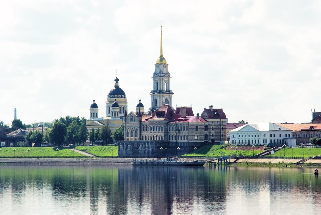
The Volga River begins in the Valdai Hills near Volgoverkhov’e in Tver Oblast, at about 228 meters. It flows east past Lake Sterzh, then through Tver, Dubna, Rybinsk, Yaroslavl, and Nizhny Novgorod. The river turns southeast toward Kazan, then south along Ulyanovsk, Tolyatti, Samara, Saratov, and Volgograd before reaching Astrakhan and the Caspian Sea.
The Caspian Sea’s surface sits roughly 28 meters below sea level. This journey showcases the Volga’s role in Russian geography.
Length, Basin Size, and Discharge Within the Russian River System
The river stretches about 3,531 kilometers and drains a basin of roughly 1.36–1.38 million square kilometers. Discharge grows from near 176 m³/s around Tver to more than 8,000 m³/s near the delta. Snowmelt contributes about 60 percent of annual flow, with groundwater near 30 percent and rain close to 10 percent.
These figures highlight how Russian waterways operate through long winters and swift spring thaws:1
| Metric | Value | Why it matters |
|---|---|---|
| Source elevation | ~228 m (Valdai Hills) | Headwaters on glacial uplands |
| Mouth elevation | ~–28 m (Caspian Sea) | Ends in an endorheic basin |
| Length | ~3,531 km | Europe’s longest river |
| Basin area | ~1.36–1.40 million km² | High share of Russia’s population |
| Mean discharge (delta) | ~8,000 m³/s | Snowmelt-driven hydrograph |
Cities Along the Volga: Tver, Yaroslavl, Nizhny Novgorod, Kazan, Samara, Saratov, Volgograd, Astrakhan
Major cities line both banks, forming a demographic spine for western Russia. Tver and Yaroslavl mark the historic upper course. Nizhny Novgorod and Kazan anchor industry and research.
Farther south, Samara and Saratov front reservoirs, while Volgograd and Astrakhan control gateways to the lower river and the Caspian. Their ports and bridges show how Russian waterways tie production, energy, and trade into one system.
Europe’s Longest River and Russia’s National River
The Volga is Europe’s longest river and widely regarded as Russia’s national river. Its scale answers what major river runs through Russia and why it dominates Russian geography rivers. From hydropower to grain exports, the Volga River in Russia remains the corridor that keeps the national market moving.
Significance of Lake Volga in Russian River System
The Volga River is the major river that runs through Russia. It originates from the Valdai Hills and flows into the Caspian Sea. The Volga River is entirely within Russia, forming the core of the Russian River System. It passes through major cities like Nizhny Novgorod, Kazan, Samara, Saratov, Volgograd, and Astrakhan. These cities are connected to inland ports and reservoirs, linking population centers.
The Volga River is approximately 3,531 kilometers long, making it Europe’s longest river. Its flow is influenced by snowmelt in the spring, later controlled by dams and reservoirs built in the Soviet and post-Soviet periods. Canals connect it to the Baltic, White, Black, and Azov seas. This makes the Volga River not just a geographical feature but also an economic and strategic one.
| Feature | Volga detail | Why it matters |
|---|---|---|
| Course | Valdai Hills → Caspian Sea (entirely in Russia) | Backbone of inland route; canals feed into it |
| Length | 3,531 km (Europe’s longest) | Sets scale for shipping, hydropower, reservoirs |
| Hydrology | Snowmelt regime; spring peak; flow regulated by dams | Defines navigation windows and power seasonality |
| Population | Urban belt Tver–Astrakhan via Nizhny Novgorod, Kazan, Samara, Volgograd | Concentrates ports, industry, logistics |
| Connectivity | Moscow–Volga, Volga–Baltic, Volga–Don → Baltic, White, Black, Azov; native Caspian | “Port of five seas” network |
| Cultural role | “Volga-Matushka”; Repin’s Barge Haulers | Iconic national symbol |
| Strategic history | Stalingrad (1942–43); canal build-out post-war | Shaped military movement and development |
Volga River Russia: Source, Mouth, and Physical Geography
The Volga River in Russia connects diverse landscapes, from forest to steppe and semidesert. It plays a important role in Russian geography, influencing water, soil, and climate. The river’s path from Tver to Astrakhan is vital for transport and ecology, highlighted by its connection to the Moscow River and canals.
Source in the Valdai Hills and Elevation Change to the Caspian Sea
The Volga River originates in the Valdai Hills northwest of Moscow. It begins at about 57.2513°N, 32.4681°E, rising from springs and peat-rich bogs. The headwaters are cool and clear, starting at 228 meters above sea level.
As it flows, the river descends to roughly 45.6950°N, 47.8975°E, where it meets the Caspian Sea. This rare inland sea is below global sea level, at about −28 meters.
This steady drop drives seasonal flow and sediment transport. It also ties the Volga River to the Moscow River and canal network, which relies on regulated levels across the watershed.
Upper, Middle, and Lower Volga Physiography
The upper reach of the Volga River runs from its source to the Oka confluence. Along the way, it passes small lakes and receives several tributaries. The Rybinsk Reservoir widens the river, creating a broad inland sea effect.
The middle reach starts at the Oka and extends to the Kama. Here, the channel deepens and slows, fed by several major rivers. South of Kazan, the Kama expands the flow, creating the Samara Bend along the Volga Hills.
The lower reach runs from the Kama to the delta. It becomes a braided plain, with frequent sandbars. This is where the river’s distributaries define its final approach to the Caspian.
| Route | Locks (typical) | Connects to | Note |
|---|---|---|---|
| Moscow Canal | — | Moskva River / Volga | Access to capital |
| Volga–Don Canal | ~145 × 17 m | Azov/Black seas | 13 locks; Volgo-Don Max |
| Volga–Baltic Waterway | ~210 × 17.6 m | Baltic/White seas | Key northern outlet |
| Unified Deep Water System | — | Links five seas | “Port of five seas” moniker |
Volga Delta Extent, Distributaries (Akhtuba, Buzan), and Unique Habitats
Above Volgograd, the Akhtuba branches off, marking the start of a vast alluvial fan. Near Astrakhan, the Buzan splits from the main stem. Over 500 channels lace a delta exceeding 7,330 square miles—Europe’s largest estuary.
Shallow bays, reed beds, and lotus lagoons host pelicans and flamingos in Russia. Brackish and fresh zones shift with wind setup on the Caspian, creating a mosaic of nurseries for fish and staging grounds for migratory birds. Within Russian geography rivers, few areas match this delta’s scale and biological value.
Climatic Zones From Forest to Semidesert Along the Course
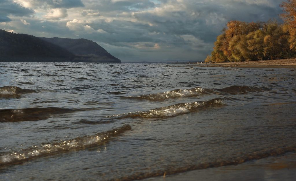
Climate bands shape the river’s hydrology from source to sea. The upper basin lies in cool, moist forest with marshy soils and long snow cover. Near Samara and Saratov, forest steppe dominates, giving way to open steppe toward Volgograd.
Closer to the Caspian, semidesert lowlands bring hotter summers, higher evaporation, and saline flats. These shifts influence reservoir operations, flood timing, and crop choices across the Volga River Russia corridor. Links to the Moscow River watershed help smooth seasonal extremes through managed flows.
Tributaries and Waterways in the Russian River System
The Volga is the backbone of the russian river system, connecting dense cities, farms, and industry. It does this through a network of russian waterways. Its tributaries and canals shape navigation, trade, and water management from the upper reaches to the Caspian basin.
Major Tributaries: Kama (Left), Oka (Right), Sura, Vetluga, Sviyaga
The left-bank Kama is the Volga’s largest feeder, bringing heavy flow from the Urals. This increases barge capacity downstream. The Vetluga adds forest-borne runoff, while the Samara strengthens the lower course.
On the right bank, the Oka channels traffic from Moscow’s orbit and central Russia. Farther east, the Sura and Sviyaga supply seasonal surges. These support reservoirs and irrigation along busy reaches.
- Kama (left): principal contributor by volume and length
- Oka (right): major navigable corridor from central regions
- Sura, Sviyaga, Vetluga: regional inputs that stabilize flows
- Additional feeders: Kostroma, Unzha, Kazanka, Kerzhenets, Bolshoy Irgiz
Navigable Links: Moscow Canal, Volga–Don Canal, Volga–Baltic Waterway
Large inland vessels can move across thousands of kilometers thanks to locks. The Moscow Canal ties the Volga to the capital’s Moskva River. This ensures year-round logistical reach.
The Volga–Don Canal links to the Don, opening routes to the Sea of Azov and the Black Sea. The Volga–Baltic Waterway connects through Lake Onega and Lake Ladoga toward Saint Petersburg. This integrates Baltic ports into the network.
- Moscow Canal: strategic access to Moscow’s market and terminals
- Volga–Don Canal: gateway to Azov-Black Sea shipping lanes
- Volga–Baltic Waterway: path to Ladoga, Onega, and northern ports
Connections to the Baltic, White, Black, Azov, and Caspian Seas
From the middle Volga, ships can route north to the Baltic and the White Sea. They can also turn south toward the Caspian. Westward links open to the Black and Azov seas, turning inland rivers into a multi-sea corridor.
This grid lets carriers stage grain, metals, and refined products across basins. It reduces rail loads and extends the practical reach of russian waterways to five seas.
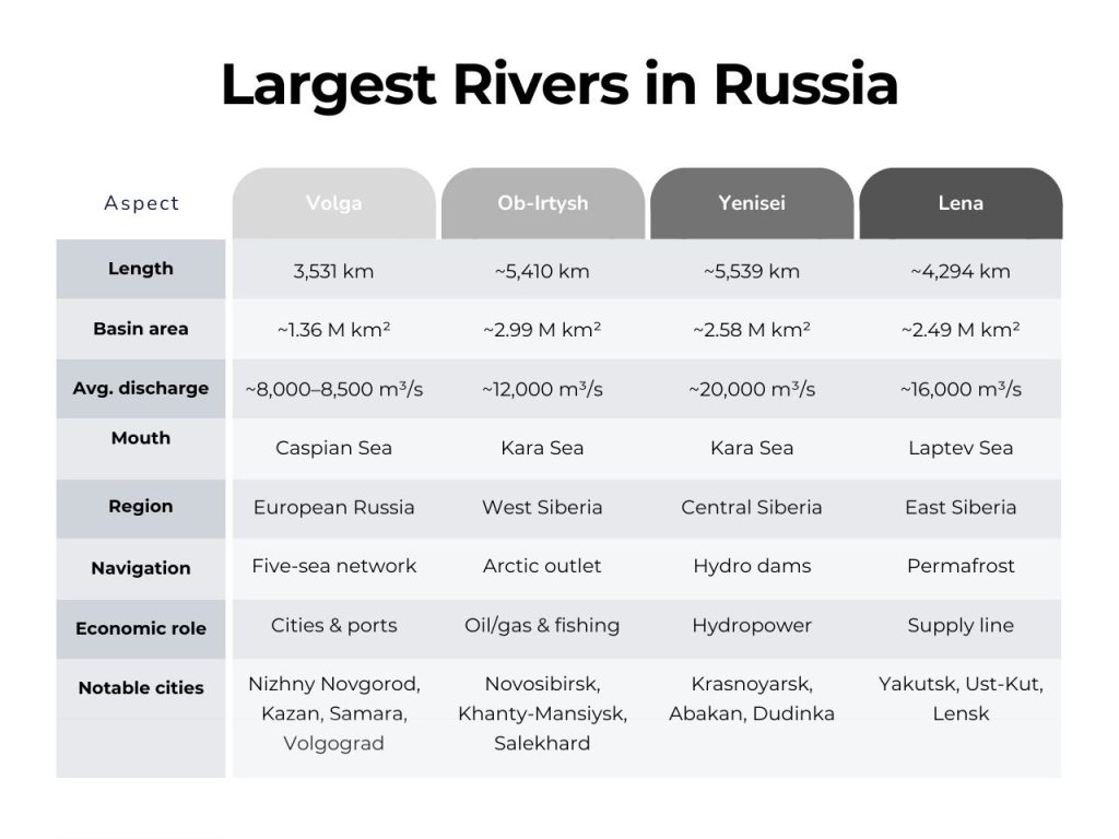
How the Volga Compares With Largest Rivers in Russia
The Volga is Europe’s longest river, yet within Russia, it yields in scale to the Ob River Russia. The Yenisei by yenisei river length, and the Lena River Siberia also surpass it. Those Siberian giants sweep to the Arctic with vast discharge and longer courses.
The Volga’s distinction lies elsewhere: a populous corridor, dense industry, and engineered links. These bind the russian river system to sea outlets. Its canals concentrate traffic and value, while the Arctic-bound systems prioritize distance and volume over connectivity.
Economic Powerhouse: Hydropower, Shipping, Agriculture, and Energy
In the heart of Russia, the Volga River supports a thriving economy. Its regulated flows and deep channels enable industry and trade to flourish. The Volga is a major player in power generation, shipping, and agriculture, connecting the Caspian basin to northern waterways. It serves as a backbone for factories, farms, ports, and energy fields from Tver to Astrakhan.
Hydroelectric Reservoirs (Kuybyshev, Rybinsk, Volgograd, Saratov, Cheboksary, Gorky, Uglich, Ivankovo)
The Soviet era saw the construction of a hydroelectric dam cascade. This chain, from Ivankovo to Volgograd, controls seasonal variations, powers industry, and irrigates vast areas. Kuybyshev Reservoir, near Samara, is one of Europe’s largest, highlighting the Volga’s economic significance.
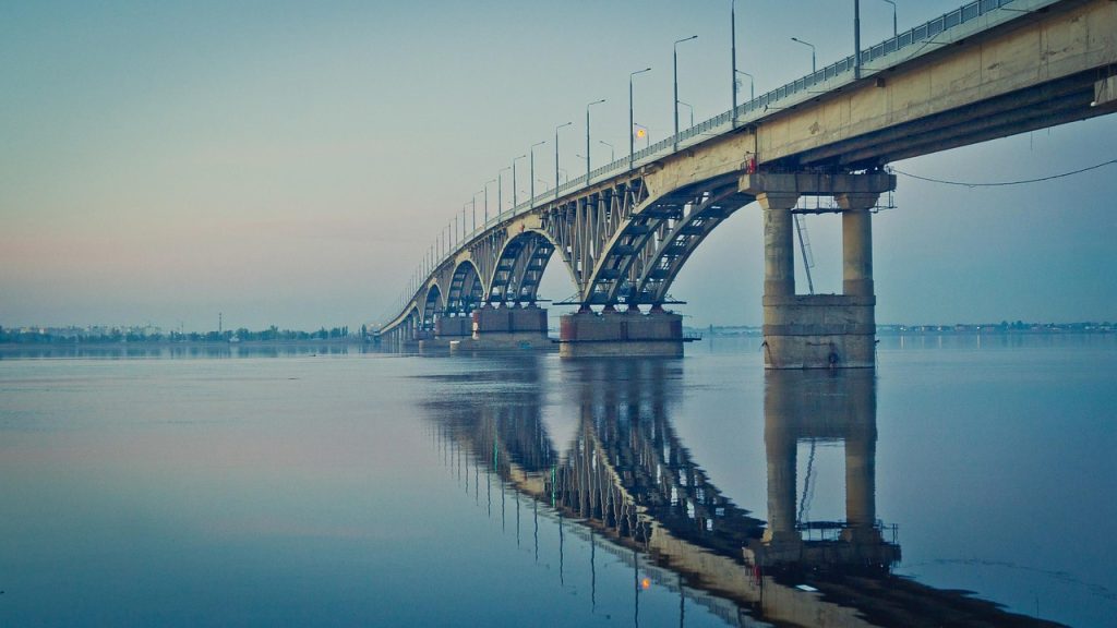
Inland Shipping Scale and Double Ship Locks Enabling Russian Waterways
Large, often double, locks facilitate continuous river flow from the upper reaches to the Caspian Sea. Barge convoys transport goods like metals, fuel, and grain, connecting Moscow to the Volga basin and beyond. This network ensures reliable and efficient transportation, making Russian waterways a vital artery.
Agricultural Heartland: Wheat Belt, Irrigation, and Fertile Floodplains
The Volga’s fertile floodplains and steppe tracts form a major wheat-producing area. Regulated water releases from reservoirs support irrigation, ensuring stable crop yields. This connection between farms and river ports solidifies the Volga’s importance in food logistics.
Petroleum, Natural Gas, Salt, Potash, and Fisheries (Including Astrakhan Caviar)
The Volga region is home to oil and gas fields, feeding refineries and pipelines. These supply domestic markets and export routes. Saline deposits provide salt and potash for chemical and fertilizer production. Fisheries, including Astrakhan’s famous caviar, are also significant, requiring careful management of Russian waterways.
Cultural and Historical Significance Across Millennia
The volga river russia holds a deep significance, embodying memory, belief, and statecraft. Its banks have witnessed the passage of legends, armies, and trade. Artists, rulers, and merchants have mapped their ambitions to its current.
Volga-Matushka in Russian Literature, Music, and Identity
Writers and painters have portrayed the river as Volga-Matushka, a maternal force. Ilya Repin’s “Barge Haulers on the Volga” immortalized labor and dignity. The folk song “The Volga Boatman” added rhythm and sorrow, echoing through time.
Today, stages from the Bolshoi to regional philharmonics continue to celebrate these themes. In schoolbooks and museums, the volga river russia reflects the national story within russian geography rivers.
Ancient Trade Routes: Scythians, Khazars, Volga Bulgaria, and Rus’ Khaganate
Classical authors described the river as Rha or Oaros. Turkic tongues named it Itil or Etil, with İdel in Tatar and Atăl in Chuvash. Caravans and longboats connected the Baltic and Scandinavia to Persia and the Arab world.
Polities emerged along its banks: Scythians and Sarmatians, followed by the Khazar Khaganate and Volga Bulgaria. The Rus’ Khaganate emerged by the ninth century. Atil, Saqsin, and Sarai became major emporia in the steppe corridor.
Battle of Stalingrad and the Volga’s Strategic WWII Role
At the great bend, Stalingrad became a siege of streets, grain silos, and quays. Control of ferries, river crossings, and the supply artery was critical. The fight tied the front to Caspian oil and the transport spine of the volga river russia.
By winter, the city symbolized a turning point. The river’s width and ice influenced tactics, logistics, and survival across russian geography rivers.
Volga Germans and Soviet-Era Transformations
Catherine the Great invited German settlers in the 18th century. Their communities built farms, mills, and towns, forming the Volga German Autonomous Soviet Socialist Republic. In 1941, wartime decrees ordered deportations to Siberia and Central Asia.
Postwar dams and reservoirs—Rybinsk, Gorky, Kuybyshev, and more—reworked the channel. Historic villages and monasteries vanished beneath new water, marking the cost of growth on the volga river russia within the network of russian geography rivers.
| Era | Names and Polities | Hubs or Works | Strategic Function |
|---|---|---|---|
| Classical to Early Medieval | Rha/Oaros (Greek, Roman); Itil/Etil (Turkic); İdel (Tatar); Atăl (Chuvash) | Atil, Saqsin, Sarai | Trade axis linking Baltic and Scandinavia to Persia and the Arab world |
| Khazar–Bulgar–Rus’ Period | Khazar Khaganate; Volga Bulgaria; Rus’ Khaganate | River customs posts, caravan stations | Revenue, tribute, and cultural exchange across steppe corridors |
| Imperial and Early Soviet | Volga Germans; Catherine the Great’s settlement policy | Farms, mills, market towns | Food supply, skilled labor, regional development |
| World War II | Battle of Stalingrad on the great bend | Ferries, quays, grain silo defenses | Transport control and access to Caspian oil routes |
| Late Soviet Modernization | Reservoir cascade on the volga river russia | Rybinsk, Gorky, Kuybyshev, Volgograd | Hydropower, navigation, and reshaped cultural landscapes in russian geography rivers |
Biodiversity and Ecology of the Volga and Its Delta
The volga river russia acts as a vibrant corridor from forest to semidesert. This gradient fosters a rich variety of species across the russian river system. Botanists have identified about 430 plant species in the basin. The delta’s wetlands are anchored by reedbeds, willows, and stands of lotus.
These habitats support a vast food web, home to roughly 400 vertebrates and over a thousand insect species. The diversity of fish is also noteworthy, with at least 127 species documented. Species like white-eyed bream, Volga lamprey, whitefish, and herrings coexist with sturgeon in the river’s channels.
Sturgeon, including Russian, beluga, sterlet, and stellate, rely on seasonal flows and clean gravels for their life cycles. This productivity supports major fisheries, with Astrakhan being renowned for its caviar, linked to the volga river russia and its delta.
Wetlands near the Caspian Sea are a critical stopover for Eurasian flyways. Around 260 bird species use these marshes, shallow lakes, and islands. Rare birds like the Dalmatian pelican, great white egret, and penduline tit breed and stopover here. The delta is also a rare habitat for pelicans and flamingos.
The delta’s diverse habitats, including channels, floodplains, and oxbow lakes, create intense primary production. Seasonal pulses of nutrients and plankton move through backwaters, supporting juvenile fish and amphibians. This cycle is mirrored by reeds that expand and retreat with water levels.
| Group | Approx. diversity | Signature species | Key habitats |
|---|---|---|---|
| Plants | ~430 spp. | lotus, reed, willow | reedbeds, floodplain meadows |
| Fish | ≥127 spp. | Russian/stellate sturgeon, sterlet, beluga | channels, spawning gravels, backwaters |
| Birds | ~260 spp. | Dalmatian pelican, herons, swans | shallow lakes, islands, mudflats |
| Invertebrates | ≥850 aquatic taxa | zooplankton, mollusks | channels, vegetated margins |
Environmental Challenges and Restoration Priorities
The Volga River is a cornerstone of russian waterways, influencing trade, culture, and ecology. Its vastness rivals the largest rivers in russia, yet it faces significant environmental strain. Efforts to manage its health are underway, addressing the various challenges it faces.
Flow Regulation, Dams, and Altered Hydrology
Reservoirs have altered the Volga’s natural flow, reducing the spring flood’s nutrient-rich waters. This change has led to sediment buildup, hindering the formation of banks and wetlands. The lower river, below Volgograd, experiences further degradation due to evaporation and diversion into side channels like the Akhtuba.
Industrial, Agricultural, and Domestic Pollution Impacts
Pollution from industry, agriculture, and urban areas has become a major concern. It contributes to eutrophication, increasing the cost of water treatment from Tver to Astrakhan. The cumulative effect of pollutants along russian waterways diminishes water quality and harms aquatic life.
Sturgeon Decline and Conservation Urgency
The decline of native sturgeons is alarming, attributed to habitat disruption and migration barriers. Overfishing and poaching have exacerbated the issue, placing several species at risk. Despite hatchery efforts, natural populations remain weak, highlighting the need for urgent conservation action.
Climate and Water-Quality Stressors: Cyanobacterial Blooms and Deoxygenation
Warmer summers and stable water levels foster cyanobacterial blooms, which can be toxic. These blooms lead to nighttime deoxygenation, harming aquatic life. Such events are common in slow-moving reservoirs and deltas, mirroring issues on the largest rivers in russia during heat waves.
- Research institutions advocate for modernizing hydraulic works to enhance environmental flows.
- Efforts to control pollution, focusing on nutrients and industrial discharges, are essential.
- Reconnecting floodplains in the delta is critical for restoring wetland productivity.
- Strengthening enforcement against poaching and regulating caviar trade is vital for sturgeon conservation.
Conclusion
The Volga is the definitive answer to the question of what major river runs through Russia. Spanning from the Valdai Hills to the Caspian Sea, it connects diverse landscapes. Canals and tributaries link Moscow to various seas, making it a vital transport artery. Cities along its path, such as Tver and Kazan, are hubs of power and commerce.
Hydropower dams, agricultural lands, and energy fields underscore the Volga’s economic importance. Reservoirs from Rybinsk to Volgograd facilitate shipping and irrigation. Fisheries, including Astrakhan’s caviar, add significant value. It stands as Europe’s longest river and Russia’s national river, connecting regions and markets.
Its historical significance is profound. Ancient routes and the Battle of Stalingrad have etched its place in history. Yet, modern infrastructure has altered its flow, reshaped wetlands, and impacted biodiversity. Efforts to clean water, manage releases, and restore habitats are underway.
The Volga is a critical lifeline and a benchmark for policy. Balancing dams, shipping, and fisheries with scientific management is significant. This will determine if the river can sustainably support energy, agriculture, and trade while preserving its delta and wildlife. For those inquiring about Russia’s major rivers, the Volga is a testament to the country’s resilience and a vital artery.
FAQs
What Major River Runs Through Russia?
The Volga River flows entirely within Russia, from the Valdai Hills to the Caspian Sea. It spans about 3,531 km, making it Europe’s longest river and Russia’s national river. Its basin is home to nearly half of Russia’s population, supporting major cities and forming the backbone of inland navigation.
Where Does The Volga River Start And Where Does It End?
The Volga originates near Volgoverkhov’e in the Valdai Hills, Tver Oblast, at about 228 meters elevation. It ends in the Caspian Sea near Astrakhan at roughly −28 meters. This makes it the world’s longest river draining into an endorheic basin.
What Is The Volga River’s Length, Basin Size, And Average Discharge?
The Volga is approximately 3,531 km long, with a drainage basin of about 1.36–1.40 million square km. Near the delta, its average discharge is roughly 8,000–8,500 m³/s. Seasonal swings range from about 5,000 m³/s to nearly 48,500 m³/s due to snowmelt.
Which Major Cities Lie Along The Volga?
Urban centers include Tver, Yaroslavl, Nizhny Novgorod, Kazan, Samara, Saratov, Volgograd, and Astrakhan. These cities form a demographic and industrial corridor central to Russian geography and trade.
How Do Canals Connect The Volga To Other Seas?
The Moscow Canal links the Volga to the Moskva River and the capital; the Volga–Don Canal connects to the Don and the Sea of Azov/Black Sea; and the Volga–Baltic Waterway reaches Lake Ladoga, Saint Petersburg, and the Baltic. These routes integrate Russian waterways into a continental network.
What Hydropower Reservoirs Operate Along The Volga?
Major reservoirs include Ivankovo, Uglich, Rybinsk, Gorky (Nizhny Novgorod), Cheboksary, Kuybyshev (Samara), Saratov, and Volgograd. They regulate flows, generate electricity, and support irrigation and shipping.
What Natural Resources And Fisheries Are Tied To The Volga?
The region holds petroleum, natural gas, salt, and potash deposits. Astrakhan’s fisheries and the Caspian Sea historically supplied sturgeon and caviar, though stocks have declined and are now tightly managed.
What Is The Cultural Significance Of “Volga-Matushka”?
“Mother Volga” reflects the river’s place in Russian identity, literature, and music, from Ilya Repin’s “Barge Haulers on the Volga” to folk songs like “The Volga Boatman.” It symbolizes endurance, commerce, and state-building.
What Was The Volga’s Role In Ancient Trade And Medieval States?
The river linked the Baltic to Persia and the Arab world. Scythians and Khazars controlled segments; Volga Bulgaria and the Rus’ Khaganate thrived on its routes; cities like Sarai and Atil became major hubs.